New York Severe Weather Alert With Tornados Possible
Sign up for our free newsletter
Subscribe to the America Report Updates to have our top stories delivered directly to your inbox.
New York City is bracing for another potentially dangerous round of severe weather only days after torrential rain flooded streets, stranded drivers and disrupted life across the metropolis. Forecasters warn that repeated thunderstorms on Tuesday could bring flash flooding, damaging winds, hail and even isolated tornadoes during the evening rush hour.
A flood watch took effect across New York City at 8 a.m. Tuesday and is scheduled to remain in force until 2 a.m. Wednesday. The National Weather Service said multiple rounds of showers and thunderstorms were expected through the evening, creating the potential for scattered severe storms and sudden flooding in New York and northeastern New Jersey.
New York severe weather peaks during rush hour
The most dangerous period is expected between approximately 4 p.m. and 11 p.m., when a cold front approaching the region could trigger several waves of powerful thunderstorms. New York City Emergency Management warned that the storms could produce heavy downpours, localized flash flooding and hazardous travel conditions.
Between one and two inches of rain could fall across parts of the city, with higher amounts possible wherever storms repeatedly pass over the same neighborhoods. Roads, highways, underpasses and other low-lying areas with poor drainage could become inundated within minutes. Officials urged residents not to walk or drive through floodwater and to allow additional time for their evening commutes.
Meteorologists are especially concerned about so-called “training” thunderstorms. The phenomenon occurs when individual storm cells follow one another over the same area like cars on a train. Even when each storm lasts only briefly, the repeated downpours can generate extreme rainfall totals and overwhelm the city’s drainage system.
The new threat comes after Saturday’s storms turned streets into rivers across parts of Manhattan and Queens. Floodwater rose rapidly in SoHo, while motorists became trapped along the Brooklyn-Queens Expressway and required assistance. The flooding struck one day before the World Cup final and came as smoke from Canadian wildfires also contributed to poor air quality.
Tropical Storm Bertha strengthens in Gulf
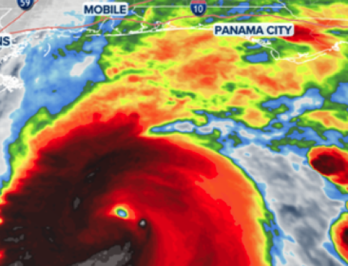
At the same time, Tropical Storm Bertha is strengthening over the Gulf and threatening a broad stretch of the northern Gulf Coast. As of Tuesday morning, Bertha was located about 100 miles south-southwest of Panama City, Florida, and 175 miles southeast of Mobile, Alabama. It had maximum sustained winds of 50 mph and was moving northwest at about 5 mph.
Tropical storm watches and warnings covered portions of Florida, Alabama, Mississippi and Louisiana, including metropolitan New Orleans, Lake Pontchartrain and Lake Maurepas. The National Hurricane Center said tropical storm conditions were possible or expected across parts of the coastline during the next 24 to 48 hours.
Bertha could bring several inches of rain, dangerous coastal flooding, rough surf and powerful currents. Because parts of the Gulf Coast have already received substantial rainfall, additional downpours could quickly produce flash flooding.
NOAA has predicted a below-normal 2026 Atlantic hurricane season, with eight to 14 named storms, three to six hurricanes and one to three major hurricanes. The agency nevertheless emphasizes that seasonal projections cannot determine whether a particular community will be struck.